| RalphBorland.net |
| Mesh |
|
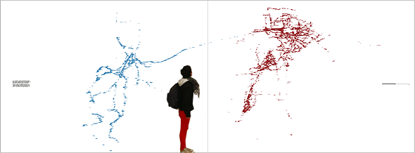
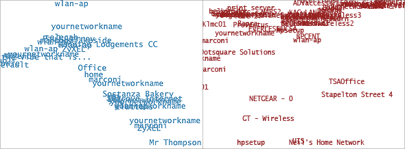
| Ralph Borland Mesh, 2008 Printed paper, with accompanying online material JAMcity group show, Cape Town 2008 (Download and view a zoomable pdf (6.5M) - mesh_scale1_10.pdf. Best viewed with Adobe Reader) For my contribution to the exhibition JAMcity (Cape Town, 2008) I produced two large-scale maps of Wifi networks in Cape Town and Johannesburg for installation in the Michaelis Gallery, University of Cape Town. The work is shown above in idealised form (photographing it is difficult because of the large difference in scale between the text and the overall image). Thanks to Daniella for being the scale model. Each map shows the name of every wifi network recorded on the WiGLE database for Cape Town and Johannesburg (more on that below) in 12 point font (about 3mm high) at their geographical positions relative to each other, for each city. The maps where printed with an architectural plotter. The vertical line separating the two city maps in the image above represents a corner, where two walls in the gallery met, as the prints were installed. Close-up images for Cape Town (on the left, in blue) and Johannesburg (right, in red) are shown below. |
|
| I'm interested in this project in the combination of small and large-scale, the intimacy of the individual network names compared to the complex shape they make in combination.The data was drawn from WiGLE - the Wireless Geographic Logging Engine, an online database that logs Wifi networks around the world, 15 million of them so far. My maps show just over 12,000 points in total. These maps are by no means complete; WiGLE is updated by individuals around the world who 'wardrive' (or warwalk, warcycle, and so on - wardance?) using portable computers and software applications to identify and record the location of Wifi networks while moving around the city. While this data is recorded and accessible in a central location like WiGLE it is not acquired from the centre - rather by many distributed local agents working independently, whose work together builds up larger (while still incomplete) pictures of an area. |
|
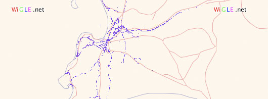
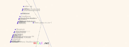
| The project required some programming to convert the data from WiGLE into something that could be printed large-scale. WiGLE's online interactive map, showing part of Cape Town in the image above, only produces low-resolution images, for viewing on your computer screen, not for printing. When zoomed out, wifi networks appear as unlabelled squares. Zooming in closer, individual network names appear, as below. |
|
| When zoomed in, it isn't possible to view an area larger than the window of their application. The network names are embedded in the image, not as text. The online application's display is no good for producing large-scale prints - but it builds the images from information on it's database, so we could query the database directly instead. Reuben Roberts wrote the code to build vector image files, which can be printed from at any scale, in the open-source format SVG, using the information on the WiGLE database. These vector files were used to make prints on an architectural plotter, which were pinned to the wall. Further to the visual pleasure of the printed maps, I was interested in drawing attention to some aspects of Wifi that I find interesting, and that will become more and more pertinent to South Africa, particularly ownership of networks, which can be community-owned, state or commercial. There is a certain politics that Wifi lends itself to: because it operates in a less-regulated part of the radio-wave spectrum, more autonomy is possible in developing tools and networks using Wifi; and because Wifi is both consumer-level technology and relatively cheap, but has a limited range (for legal or regulatory reasons), it has led to individuals joining their units together to make larger networks with further reach, networks over which they have greater control than if they were leasing them from another body. With the rise of political organising over networks, using applications like SMS or Twitter or email, taking control of the networks themselves is a logical next step.The combination of autonomy and collectivity that Wifi networks enable is intriguing, both for the material structures that result from it, and for ideas it suggests about technology use, economic and social models, communities and individuals, centralisation vs. distribution, and the regulation of telecommunications. This paper is worth reading for an exploration of the politics of Wifi: 'Society in ad-hoc mode: Decentralised, self-organising, mobile' by Armin Medosch There are community-owned Wifi networks in Cape Town and Johannesburg, including these two: C.T.Wug - Cape Town Wireless User Group JAWUG - Johannesburg Area Wireless User Group
Thanks to Rowan Smith for project management and installation in Cape Town, and to Reuben Roberts.
|